
Much like our football team, in recent weeks a cold front rolled through much of the central US. It took no prisoners, and left frigid temperatures in its wake. I find it interesting how disconnected weather forecasts can make you to the outside environment. When I left the enveloping warmth of my dorm room on a Wednesday morning, I told myself, “-2 degrees outside isn’t the worst thing and surely a 10-minute walk to class can’t be much worse.” The thermal assault via bitter winds and frigid air that unfolded on that walk made it clear that thought would age more like milk than wine.
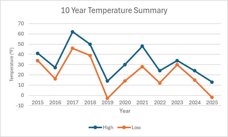
Now that we’re back to (comparatively) balmy temperatures of mid 30’s, perhaps an obvious question lingers, why? Well, the first step of my slightly underqualified research was to compare recent meteorological trends with historical data sourced from the Port Columbus International Airport. For the visual pleasure of you, the reader, I compiled the high and low temperatures for January 21st over the past 10 years into a chart in the hopes that it might be at least somewhat enlightening. While no discernible trend emerges over the past decade per se, I can say that the low temperatures we experienced ranked as some of the coldest compared to the temperatures at this time of January in the past decade. So, what’s the cause? Well, long story short, we don’t know. More specifically, there’s two major phenomena that could be the cause but we’re just not certain.
Don’t let the name fool you. Our first suspect, La Niña, is far more fearsome than its name implies (which translates to “little girl” in Spanish). La Niña, like its related sibling El Niño, is a climate pattern that occurs in the Pacific Ocean. Both patterns have opposite effects, but during La Niña events warmer waters get pushed toward Asia which pushes the jet stream more north. This leads to warmer winters in the south and more consequential for us, cooler winters in the North. (For further explanation of El Niño and La Niña, this article explains both well in simple terms.) According to a NOAA report back in October of 2024, La Niña was favored to be influential in the upcoming (now present) winter. However, La Niña may not paint the whole picture here.
Our second suspect, this time with a far more menacing name, carries the moniker of a polar vortex. Unlike La Niña, the polar vortex maintains a constant system of cold air and low pressure at both of Earth’s poles. The colder air of the polar vortex typically doesn’t leave the poles due to the counterclockwise airflow that keeps it there (hence “vortex”), but its strength oscillates with the seasons, getting stronger in the winter and weaker in the summer. As it strengthens, it also expands which has the result of sending arctic air southward into Canada and the northern US. (Again, here’s another article that explains it well.) Just before the recent cold snap, a forecast was released on climate.gov that forewarned the possibility of the vortex expanding its reach over Canada and the Hudson Bay. This expansion would push the jet stream southward and would allow Arctic air to pour into the continental US. Although this theory is plausible, other factors besides the polar vortex could be responsible for the jet stream’s downward shift. (Full report can be found here.)
While “we don’t know” may not be the most satisfying answer to this conundrum, there are several phenomena at play whose ramifications are not fully understood or quantified. Regardless of the justification for the recent cold snap, it serves as an important reminder of the seriousness of harsh winter weather and that -2 degrees is a lot colder than it sounds.
Leave a Reply